
Google Maps and Google Earth Street
View
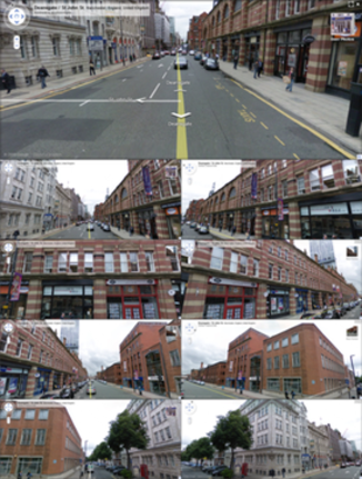
A road junction in
Manchester, England, showing nine angles. |
|
Initial release |
May 25, 2007; 5 years ago |
|
Stable release |
Release 67 (see
list) / November 28, 2012; 6 days
ago
Botswana
Svalbard
Cambridge Bay |
|
Available in |
Chinese,
Croatian,
Czech,
Dutch,
English,
French,
German,
Italian,
Japanese,
Polish,
Portuguese,
Romanian (beta),
Spanish |
|
Website |
Google Street View |
Google Street View is a technology featured in
Google Maps and
Google Earth that provides
panoramic views from positions along many streets in the world. It
was launched on May 25, 2007, in several cities in the United States,
and has since expanded to include cities and rural areas worldwide.
Where available, Street View images appear after zooming in beyond
the highest zooming level in maps and satellite images, and also by
dragging a "pegman" icon onto a location on a map. When dragging the
pegman icon, blue lines on the map showing Street View imagery will
appear. Using the
keyboard or
mouse, the horizontal and vertical viewing direction and zoom level
can be selected. A solid or broken line in the photo shows the
approximate path followed by the camera car, and arrows link to the next
photo in each direction. At junctions and crossings of camera car
routes, more arrows are shown. By using
Google Maps, users can turn on
steroscopic 3D mode by right-clicking in Street View to get an
anaglyph version of any Street View images. However, this mode
requires users to wear red
cyan
glasses to see the 3D effects.[1]
On November 21, 2008, Street View was added to the Maps application
installed on the Apple
iPhone.
On December 10, 2008, Street View was added to the Maps application for
S60 3rd Edition. Street View has now also been added to the
BlackBerry and
Windows Mobile versions of Google Maps. All versions of
Google Maps for the
Android operating system feature Street View, and the digital
compass can be used to look around the locations.
Google Street View displays panoramas of
stitched images taken from a fleet of specially adapted cars. Areas
not accessible by car, like pedestrian areas, narrow streets, alleys and
ski resorts, are sometimes covered by Google Trikes (tricycles)[2]
or
snowmobiles.[3][4]
On each of these vehicles there are nine directional cameras for 360°
views at a height of about 8.2 feet, or 2.5 meters,
GPS units for positioning and three laser range scanners from
Sick AG
for the measuring of up to 50 meters 180° in the front of the vehicle.[5]
These are used for recording a rough 3D model of the surroundings,
enabling faux-3D transitions between distinct panoramas where the
environment images are momentarily mapped onto this 3D model while being
crossfaded to create an animated perspective change as the user travels
from one panorama to another. There are also
3G/GSM/Wi-Fi
antennas for scanning 3G/GSM and Wi-Fi
hotspots.[6]
More recently, high quality images have been based on
open source hardware cameras from
Elphel.[7]
Development
Google Street View was introduced in the United States on May 25,
2007 and, until November 26, 2008, featured camera icon markers, each
representing at least one major city or area (such as a park), and
usually the other nearby cities, towns, suburbs, and parks. Many areas
that had coverage were not represented by icons.
- On May 12, 2008, Google announced that it was testing
face-blurring technology on its photos of the busy streets of
Manhattan.[8]
The technology uses a computer algorithm to search Google's image
database for faces and blurs them, according to John Hanke, director
of
Google Earth and
Google Maps.[9]
- On April 16, 2008, Street View was fully integrated into
Google Earth 4.3.
- On July 2, 2008, Street View was introduced in
France
and Italy,
providing the first service outside the United States and the debut
of Google's new 4th Generation Cameras.
- On August 4, 2008, 28 icons of major metropolitan areas of both
Australia and
Japan
were added.
- On December 1, 2008,
New Zealand was added to Google Street View. Faces were blurred
upon recommendation by the New Zealand Privacy Commission
- Two other features included in the June 10, 2008, update were a
mask of the "Google Car" and the application of face-blurring
technology on all photos
- On November 26, 2008, the Street View button and all the camera
icons were removed. Instead of clicking the "Street View" button,
this is now accessed using the "pegman" button in the left hand
corner. When the "pegman" icon is dragged over the map blue
polylines appear where Street View is available and a small window
will show the current Street View. If this is dropped on the map the
Street View opens and takes over the whole map window.
- On April 9, 2009, Street View became available with a
full-screen option.
- On June 5, 2009, Smart Navigation was introduced which allows
users to navigate around the panoramas by double-clicking with their
cursor on any place or object they want to see.[10]
- On January 14, 2012, users of versions lower than Google Earth
6.0 are blocked from seeing Street View content. This is done to
promote version 6.[11]
Timeline
Coverage

Countries and dependencies with full or partial
coverage
Countries and dependencies with full or partial
coverage planned (official)
Countries and dependencies with full or partial
coverage planned (unofficial)
Countries and dependencies with museum views
only
Countries and dependencies with no current or
planned coverage
Google Street View was introduced in the United States on May 25,
2007,[12]
and only covered areas of the United States until July 2, 2008. Images
can now be seen in 48 countries, dependencies, and autonomous regions
(although parts of other countries and dependencies can be seen from
locations located near national borders; for example, large portions of
Vatican City can be viewed from Rome's street view). Introductions
have generally occurred every 2 days to 100 days. Until November 26,
2008, major cities (and early on, the only cities) were marked by camera
icons, more of which were added each time. Then, all camera icons were
discontinued in favor simply of "blue" coverage, while other features
have been added to make access to and use of the feature more
user-friendly.
On June 6, 2012 Google announced that it has captured 20 petabytes of
data for Street View, comprising photos taken along 5 million miles of
roads, covering 39 countries and about 3,000 cities.[13]
Table
Below is a table showing the countries available on Street View and
the year they were first added. Italics indicate a non United
Nations member state, and Bold indicates a territory that
includes non-museum views. Plain text indicates that a country has
museum views only.
 Åland
Islands Åland
Islands |
2010 |
First semi-autonomous
region available on Street View. |
 Andorra Andorra |
2012 |
|
 Antarctica Antarctica |
2010 |
While in Antarctica, the
Pegman is shown as a
Chinstrap Penguin. Antarctica also has the southernmost
place in the world accessible by Street View. |
 Australia Australia |
2008 |
Added on the same day as
Japan;
first country available in
Oceania. |
 Austria Austria |
2012 |
Only
Museum views and ski resorts |
.svg/22px-Flag_of_Belgium_(civil).svg.png) Belgium Belgium |
2011 |
|
 Botswana Botswana |
2012 |
Most recent country added |
 Brazil Brazil |
2010 |
First country available in
South America. Cities in twenty-two Brazilian States are
available (from a total of twenty-six States and one Federal
District), along with views of the
Amazon River near
Manaus city, in the
Amazonas State. |
 Canada Canada |
2009 |
Areas are available in every province and territory to a
certain extent |
 Chile Chile |
2012 |
|
 Croatia Croatia |
2012 |
|
 Czech
Republic Czech
Republic |
2009 |
|
 Denmark Denmark |
2010 |
|
 Estonia Estonia |
2012 |
|
 France France |
2008 |
Added on the same day as
Italy,
one of the first two countries available in
Europe. |
 Finland Finland |
2010 |
|
 Germany Germany |
2010 |
Only some big cities are available, such as
Berlin,
München,
Hamburg,
Düsseldorf,
Hannover,
Cologne,
Essen,
Dortmund,
Dresden and
Leipzig. |
 Greece Greece |
2012 |
Museum views only. |
 Hong
Kong Hong
Kong |
2010 |
First place with Street View in mainland Asia, along with
Macau. |
 India India |
2012 |
Museum views only. |
 Iraq Iraq |
2011 |
Museum views only. |
 Ireland Ireland |
2010 |
|
 Isle
of Man Isle
of Man |
2011 |
|
 Italy Italy |
2008 |
Added on the same day as
France, one of the first two countries available in
Europe. |
 Israel Israel |
2012 |
First country in the Middle East with Street View (not
counting museum views in Iraq). |
 Japan Japan |
2008 |
First country available in
Asia.
Added on the same day as
Australia. |
 Jersey Jersey |
2011 |
|
 Latvia Latvia |
2012 |
|
 Macau Macau |
2010 |
First place with Street View in mainland Asia, along with
Hong Kong. |
 Mexico Mexico |
2009 |
First
Latin American country to be added to Google Street View. |
.svg/24px-Flag_of_the_Midway_Islands_(local).svg.png) Midway Islands
Midway Islands |
2012 |
First American overseas territory available |
 Monaco Monaco |
2011 |
Smallest country available on Google Street View. |
 Netherlands Netherlands |
2009 |
First fully covered country. |
 Norway Norway |
2010 |
Has the northernmost place in the world accessible by Street
View. |
 New
Zealand New
Zealand |
2008 |
Most of the country is covered. |
 Poland Poland |
2012 |
Piotrkowska Street,
Łódź,
was the only area available on the release date. Most major
cities and some major roads and tourist attractions were added
in the next update one month later for
UEFA Euro 2012. |
 Portugal Portugal |
2009 |
|
 Qatar Qatar |
2012 |
Museum views only. |
 Romania Romania |
2010 |
|
 Russia Russia |
2011 |
Museum view only until 2012, now has areas of
Moscow,
St. Petersburg, small parts of
Kazan,
and other areas. First ex-Soviet
country available. |
 San
Marino San
Marino |
2012 |
|
 Singapore Singapore |
2009 |
First
Southeast Asian country available. |
 Slovakia Slovakia |
2012 |
|
 South
Africa South
Africa |
2010 |
First country available in
Africa. South Africa,
Botswana and the
Canary Islands are the only available territories in Africa. |
 South
Korea South
Korea |
2012 |
Areas in and around
Seoul
and
Busan are available. |
 Spain Spain |
2008 |
|
|
Svalbard |
2012 |
Featuring snow mobile views |
 Sweden Sweden |
2010 |
|
 Switzerland Switzerland |
2009 |
|
 Thailand Thailand |
2012 |
Currently available in
Bangkok,
Chiang Mai and
Phuket. |
 Taiwan Taiwan |
2009 |
First non-United
Nations country available. |
 Ukraine Ukraine |
2012 |
Added before starting of
UEFA Euro 2012 and it is available in
Kiev,
Lviv,
Donetsk,
Odessa and
Kharkiv. |
 United
Kingdom United
Kingdom |
2009 |
|
 United
States United
States |
2007 |
First country available to view on Street View, as well as
the only one available for over a year following Street View's
initial release. Currently has more total coverage than any
other country available. |
North America
United States
The United States was the first country to have Street View images
and was the only country with images for over a year following
introduction. Early on, most locations had a limited number of views,
usually constrained to the city limits and only including major streets.
Few suburbs or other nearby cities were included. After the first few
sets of introductions, image collections from cities added were more
detailed, often including every side street, more suburbs and nearby
cities.
Canada
In Canada, Google Street View cars had been spotted as early as
September 2007, in
Montreal, though service for Canada was delayed while attempting to
settle with the Canadian government over its privacy laws. The first
images of Canada were made available on October 7, 2009. Currently, most
of Canada can be seen on Street View with the notable exceptions of
Labrador, the
Gaspé Peninsula and
Fort McMurray,
Alberta.
On February 10, 2010, many more areas of Canada (barring extremely
northern and rural areas) were added. Of note, ski runs on
Whistler Blackcomb Resort were also covered in this update. As of
November 28, 2012, the northernmost community currently imaged is
Cambridge Bay,
Nunavut,
and the second northernmost place in North America, after
Deadhorse Airport near
Prudhoe Bay,
Alaska.[2]

Google Trike in Cambridge Bay, Nunavut, August 2012
Latin America
Mexico
In Mexico, first reports of sightings came in from Tijuana as early
as July 2007 and now Google Street View cars are being spotted in many
Mexican states. On November 9, 2009, Street View was made available in
the main cities of Mexico, including
Mexico City,
Guadalajara,
Monterrey,
Puebla,
Cancún and
Puerto Vallarta.[14]
Brazil
On September 30, 2010, the first cities from Brazil were added.[15]
The service started with 51 cities, most from
São Paulo, Rio de Janeiro, Minas Gerais and greater metropolitan
areas. Historic cities such as
São João del-Rei,
Ouro Preto,
Diamantina and
Tiradentes were also included. On September 28, 2011 several towns
in the states of Paraná, Santa Catarina and Rio Grande do Sul were
added. In August 2012, 77 more cities - mostly from Northeast and
Midwest regions - were added to the service,[16]
including traffic status. Fortaleza, Campinas, Brasília, Salvador and
Porto Alegre are available for traffic checking as well.[17][18]
Europe
In Europe, coverage is available in 23 countries, of which 16 have
complete or near-complete coverage. Coverage began in Europe on July 2,
2008, with the
Tour de France route in parts of France and Italy, and other parts
followed.
Asia
In Asia, Google Street View is currently available in parts of
People's Republic of China (Hong
Kong,
Macau),
Israel,
Japan,
Singapore,
South Korea,
Republic of China (Taiwan) and
Thailand.
Oceania
On August 4, 2008, the image collection of Australia was introduced.
Extensive mapping of New Zealand was included on December 1, 2008.
Africa
Street View can be seen in
South Africa,
Botswana and the
Canary Islands of Spain. It has also been planned for
Lesotho.
Antarctica
In September 2010, views of
Half Moon Island in the
South Shetland Islands were added.[19]
Future
In September 2011, Google announced plans to shoot photos of
tourist attractions in
Malaysia using the Street View trike.[20][21]
On February 23, 2012 Google announced plans to incorporate 360
underwater views of Australia's
Great Barrier Reef into its Seaview project. The scientific
expedition using specialized cameras will begin in September 2012 and
the 360 degree views are planned to go live in February 2013.[22][23][24]
The Brazilian
Amazon rainforest project is scheduled to go live in March 2013.[24]
On November 23, 2012, Google in cooperation with Indonesian Tourism
Ministry has officially launched the first Google StreetView vehicle in
Indonesia starting in the capital city
Jakarta[25].
Google said that it is the biggest project in Asia to date and will
feature several big cities in Indonesia as well as a special project
featuring top tourist attractions.[26]
A list of the places Street View vehicles are currently driving, or
where Street View is officially planned:[27]
Google announced in mid-June 2012, that they will be launching a
"street view" for hiking trails to debut in the near future.[38]
Cameras
Google has used three types of car-mounted cameras to take Street
View photographs. Generations 1–3 were used to take photographs in the
United States. The first generation was superseded and images were
replaced with images taken with 2nd and 3rd generation cameras. Second
generation cameras were used to take photographs in Australia. The
shadows caused by the 1st, 2nd and 3rd generation cameras are
occasionally viewable in images taken in mornings and evenings. The new
4th generation cameras will be used to completely replace all images
taken with earlier generation cameras. 4th generation cameras take
near-HD images and deliver much better quality than earlier cameras.
Even though 4th generation cameras were in use as early as April 2008,
Google used older cameras for many areas as late as October 2009 for
Street View and as late as September 2010 for Museum View.
In October 2008, Google introduced the Street View Trike, a pedal
tricycle with a 4th generation camera mounted to take images where
cars cannot reach, including footpaths and dirt tracks.[39]
The 250-pound, 9-foot long tricycles are piloted by athletes.[40]
All Street View images taken now will be taken with the 4th generation
Street View cameras.
In February 2010, Google introduced the Street View
Snowmobile, a snowmobile with a 4th generation camera mounted to
take images on the Whistler Blackcomb Ski Slopes in preparation for the
winter olympics in Vancouver, Canada.[41]
Google plans to use 4th generation cameras to re-shoot areas
previously covered by earlier versions. Google uses the open-source
cameras from
Elphel
for capturing Street View photos.[42]
As of June 2012, most of the United States, much of Australia, Japan,
and New Zealand, a couple areas in France and Italy, some very small
areas in Canada and Mexico near the U.S. border, and a few museums
around the world still have low resolution images. Everywhere else
covered by Street View has either always had HD images or has had its
low resolution images replaced by HD images.
-
Street View Camera showcased on campus.
Camera
quality comparison
|
|
 |
|
| Prior low resolution photo (used from April 2007 - September
2010) |
New high resolution (HD) photo (used from April 2008 –
present) |
The above shows a comparison of different generations of the Street
View cameras. The first image was taken with the 2nd generation Street
View camera and the second image was taken with the 4th generation
camera. Noticeably, the 4th generation camera provides clearer, sharper,
and more vivid images than its predecessors. In most of Europe, for
example, images were taken with the 4th generation camera as they were
taken later. Images taken with 1st, 2nd, and 3rd generation cameras are
gradually being phased out and replaced by images taken with 4th
generation cameras. Eventually, all low resolution images will be
replaced with HD images.
Pegman
For most areas on street view, the pegman is shown as a standard
yellow figure. However, some areas have a modified version for specific
areas. For example, in
Legoland (California) the pegman is shown as a
Lego
character, in
Hawaii
the pegman is a
surfboarder, and on
Half Moon Island (Antarctica)
the pegman is shown as a
Chinstrap Penguin.[43]
In certain stadiums and sports facilities, the pegman appears with
sportswear when dropped in the map, such as in Arthur Ashe Stadium in
Corona Park, Queens, NY. When Quest mode is enabled and Maps GL is
disabled, the pegman is shown in the style of a video game character,
and when dropped on NASA's Kennedy Space Center, the pegman is shown as
an astronaut.
Privacy issues
Privacy advocates have objected to this Google feature, pointing to
views found to show men leaving strip clubs, protesters at an abortion
clinic, sunbathers in bikinis, and people engaging in activities visible
from public property in which they do not wish to be seen publicly.[44]
The concerns have led to several temporary bans of Street View in
countries around the world. Google maintains that the photos were taken
from public property; however, an individual taking pictures of private
property using a ladder to gain a view not normally available to a
pedestrian would be prosecuted for invasion of privacy or harassment in
many jurisdictions worldwide. Google has yet to address this concern.
The service also allows users themselves to flag inappropriate or
sensitive imagery for Google to review and remove.[45]
In May 2010, it was revealed that Google had collected and stored
payload data from unencrypted Wi-Fi connections as part of Street View.[46]
German authorities are considering legal action while the Foreign
Minister said "I will do all I can to prevent it." Australian police
have also been ordered to investigate.[47][48]
Discontinued
regions
In October 2010, Google Street View ceased operations in Australia,
following months of investigations from Australian authorities.[49]
However, this cessation has since ended, with Google announcing plans to
continue production on May 4, 2011[50]
and subsequently releasing updated Street View imagery for Australian
towns and cities on July 27, 2011.[51]
In April 2011, Google decided to stop taking Street View images in
Germany.[52]
In June 2011, Google decided to temporarily stop taking street images
in India, after receiving a letter from the local authorities.[53]
Competing products
Artistic uses
of images
Fine-art photographers including Mishka Henner, Nick Mason, Aaron
Hobson, Jon Rafman, Doug Rickard, and
Michael Wolf have selected Google Street View images for use in
their own work.[54][55][56][57][58][59]
Although the images may be
pixelated, the colours "muddy", and the perspective "warped", the
photographs have been published in book form and exhibited in art
galleries.[56][57][60]
Wolf won an honourable mention in Daily Life in the 2011
World Press Photo competition for some of his work using Google
Street View.[61]